thursday, october 16, 2008
A map of three summers in the Bay Area
Here’s a book I made recently for my book arts class. I’ll talk about my other classes at some point too.
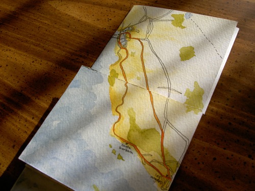
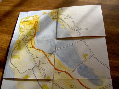
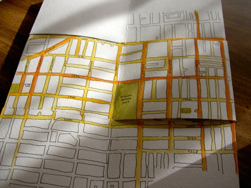
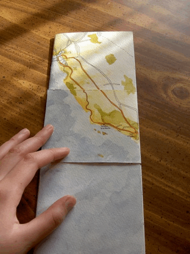
This is a tetra-tetra flexagon that folds open three times to zoom in from California to the Bay Area to San Francisco to the Mission/Castro area. A flexagon sounds fancy but it’s just one piece of paper cut and folded in a certain way — here are directions for making your own (it’s easy, but it helped me to see them in person first).
This map only covers what I know. I labeled the cities and neighborhoods that I’m familiar with, and I left areas blank if I haven’t spent much time there. (Except I left parts of the Mission/Castro blank because I’d gotten tired of tracing and painting.)
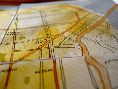
A darker yellow background means I’ve spent more time in that area. A darker orange freeway or street means I’ve traveled along it more often. Green means a park.
So, this book is a way to look at my three summers during college, focused on the past two summers because I couldn’t put the Sunset, the Mission, and the Castro together on one spread. If you fold up the map from its fully open state above, it tells a kind of story:
[4: Mission/Castro] I lived at 18th & Valencia in summer 2007 and 19th & Collingwood in summer 2008 (and 41st & Irving in summer 2006), and I spent a lot of time near those places. [3: San Francisco] I wandered around the city on weekends. [2: Bay Area] On weekday mornings I walked to the Yahoo! shuttle stop at 16th & Mission and rode to Santa Clara, and on weekday evenings I returned the same way. [1: California] At the beginning of each summer, I went from Santa Barbara to Los Angeles for a couple weeks since that’s my home, and then I went up to San Francisco. At the end of the summer, I returned from San Francisco to Los Angeles and then went back to school in Santa Barbara. I work part-time remotely from here.
An animation of reading the book, starting with it closed:
This book also ties in with the Flickr photo map of my summer photos and seeing the Bay Area from above when flying to New Jersey for a few days during the summer, when my grandpa was dying, which is the part of my summer that the map doesn’t reflect.
comments (12)
thursday, march 22, 2007
It’s OK enough to show the world
My final assignment for New Media class was to use Flash to create a “new media work” that “uses a diagram or map as its interface”. I know that the only good Flash movies are entertaining (see monkey pops, la historia del mamut, etc.), but of course I tried to make something informative and useful — while wondering why I was having such a hard time. This is the result:
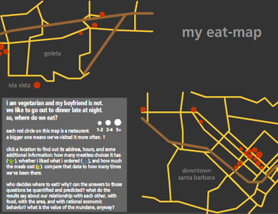
It’s an eat-map (ha ha, like heat-map) of the Santa Barbara area: a bunch of mini-reviews of restaurants I’ve visited with Doug. Then I wrote five pages about the implications of this project:
…my eat-map displays narratives, facts, words, and images in order to both memorize and communicate…these mundane facts are collected and pored over as ways to more efficiently exchange money for satisfying experiences…by putting these experiences into information, I reveal the shapes and forms within them: a spatial memory of where restaurants are, shaped into a map; a knowledge of how often we go out to eat, reduced into the sizes of circles…blah blah blah.
If you don’t want to bother with new media, here is my list of good places in the Santa Barbara area, ordered by closing time:
- Andersen’s — 9 pm
- Fresco — 9 pm (Sun closed)
- Dish Cafe — 9 pm (Sun closed)
- Playa Azul Cafe — 9 pm (Fri-Sat 10 pm)
- Flavor of India — 10 pm (Fri-Sat 10:30 pm, Sun closed)
- Sojourner Cafe — 11 pm (Sun 10 pm)
- Paradise Cafe — 11 pm
- Blue Agave — 11:30 pm
- Woodstock’s — 12 am (Fri-Sat 1 am)